Radar is one of the most important tools that meteorologists, or those interested in the weather, use on a day-to-day basis.
Not only does radar help show when rain or a thunderstorm will arrive, but it can detect wintry weather and snow, wind speed and rotation within a storm to identify a tornado and even identify other phenomena, like birds, insects or traffic.
NEXRAD (Next-Generation Radar) is a network of 160 high-resolution Doppler radars across the United States operated by the government, including the National Weather Service, NOAA, the FAA and the military.
While NEXRAD is an extensive network, there are still gaps in coverage. That is where private companies, TV stations and universities have stepped in.
What is a radar gap?
A ‘radar gap’ is an area with poor or no lower-level (below 10,000 feet) radar coverage. There are a few reasons for these gaps in coverage in the U.S., whether it’s because of terrain, budget or just a sparsely populated area.
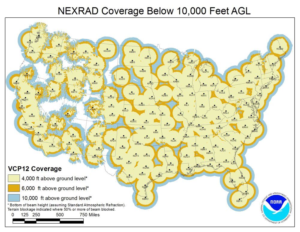
On the map below, you can see areas across the contiguous U.S. where there is radar coverage, whether it is excellent or non-existent.
NOAA radar coverage below 10,000 feet across the U.S. (NOAA)
The best coverage is for those who are closest to radars, since that will give you the closest depiction of what is actually happening on the ground.
The further you are from a radar, the higher above ground level that scan is being done. That is because radar beams don’t follow the curvature of the earth, so with distance, the radar beam increases in height.
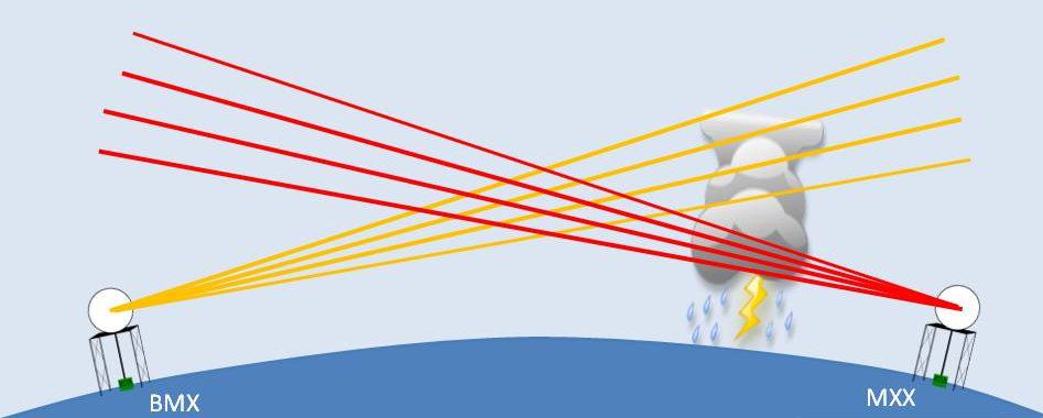
Illustration of radar beams gaining height with distance from a radar. (NWS Birmingham)
Why is that a problem? Severe and tornadic storms can have much lower cloud bases than 10,000 feet, so in some areas, severe weather can go undetected by radar.
Fixing the problem
In theory, fixing the radar gap issue across the U.S. is easy, right? Just add more radars. Unfortunately, it’s not a quick-fix, but one company is doing just that.
Climavision, a company based out of Louisville, Ky., is aiming to improve weather forecasting by adding a network of more than 200 weather radars to fill existing radar gaps.
They will strategically place radars in the Southeast, Midwest, Northeast, Western U.S. and Alaska. Climavision currently has 6 radars operating across the Southeast U.S. and expects to have 35 by the end of 2023.
So, what are the problematic areas? Areas in radar gaps that are prone to weather disasters include the Southeast U.S., where tornadoes are common and there are many rural communities with manufactured homes.
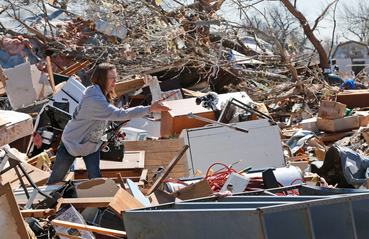
A destroyed mobile home after a tornado moved through. Manufactured homes are extremely vulnerable to damage and destruction from severe storms. (AP Photo/Sue Ogrocki)
The western U.S. may not be at the same risk of severe weather as the Midwest and Deep South, but according the Climavision CEO and Founder Chris Goode, “the lack of radar coverage can diminish the ability to quickly detect the growing number of devastating wildfires and to anticipate flash flooding that often follows the burn scars.”
Climavision expects that adding radars into these gaps will not only help improve lead-times for warnings that may have gone undetected in the past.
Goode said he “hopes to significantly improve weather forecasting and deliver weather intelligence that will strengthen our society’s ability to respond to and recover from weather challenges and disasters.”
Along with Climavision, TV stations and universities have also installed radars to supplement NEXRAD sites, including Spectrum News 13 and Bay News 9, which have two Klystron Doppler radars in Central and Western Florida.
In 2017, the University of Louisiana-Monroe installed a radar at the airport nearby, filling a radar gap in northeast Louisiana, giving better coverage for southeast Arkansas and the Mississippi Delta.
ULM’s radar data is available to the National Weather Service, helping them provide better warnings for a severe weather prone area that had poor radar coverage prior to the radar being built.
Our team of meteorologists dives deep into the science of weather and breaks down timely weather data and information. To view more weather and climate stories, check out our weather blogs section.