A powerful storm system moves east on Wednesday, bringing showers and storms to the state of Florida. Here’s what you need to know as we head throughout our midweek.
A powerful area of low pressure is ejecting out of the heartland of the country on our Tuesday and quickly racing it’s way towards the northeastern United States. As this low pushes east, it’s bringing some fiesty storms with it to the mid-atlantic coast through north central Florida.
Ahead of this line, a strong and powerful sub-tropical jetstream is streaming over Central Florida from southwest to northeast. Winds just 5,000 feet above our head are approaching 50-60 mph and climb to nearly 100 mph just over 10,000 feet above our head. These strong winds will allow for a gusty day before the storms arrive in Central Florida, with many across the region experiencing winds gusting up to 40 mph throughout the day. A Wind Advisory is now in effect for all of Central Florida through Wednesday evening.
On top of strong winds feeding storms, bountiful storm fuel will also exist through the region. With temperatures starting off in the lower 70s across Central Florida, they’ll quickly rise into the mid and upper 80s around and south of Interstate 4. Those north of I-4 in Marion and Lake counties could find highs in the upper 70s, as the cold front arrives earlier in the day for those areas.
With added heat aiding growing storm fuel, and with a very strong jet stream providing wind energy, our cold front is likely to maintain – or even strengthen – it’s intensity as it moves through the Central Florida area on our Wednesday afternoon through Wednesday evening, before we begin to dry out late Wednesday night.
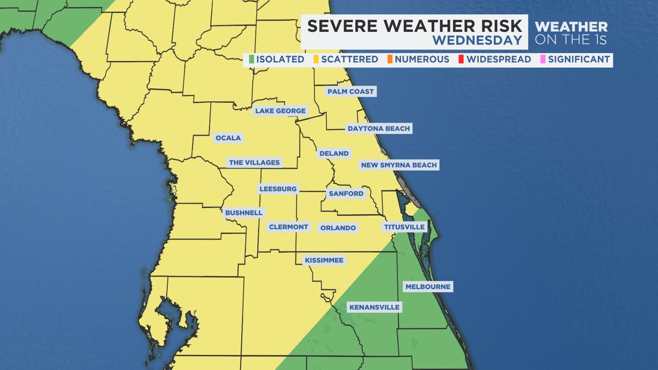
Timing and Threats
This cold front is likely to be a bit stronger than previous fronts over the past couple of months. With all our severe ingredients in place, and with the passing of the front during peak daytime heating hours, all modes of severe weather are on the table. With that said, the most likely impacts look to be strong damaging winds in excess of 60 mph, frequent lightning, heavy rainfall capable of localized flooding in poor drainage areas, and the chance for a few coin size hail stones in the strongest storm or two.
While a very low end tornado threat does exist, the best wind shear will be found across the North Florida panhandle. We’ll monitor the cold front to see if any kinks along it could spin up a brief funnel cloud, but the tornado threat does seem to be very low for the Central Florida area.
The front is set to enter Central Florida around our lunch time, moving it’s way from north to south and from west to east.
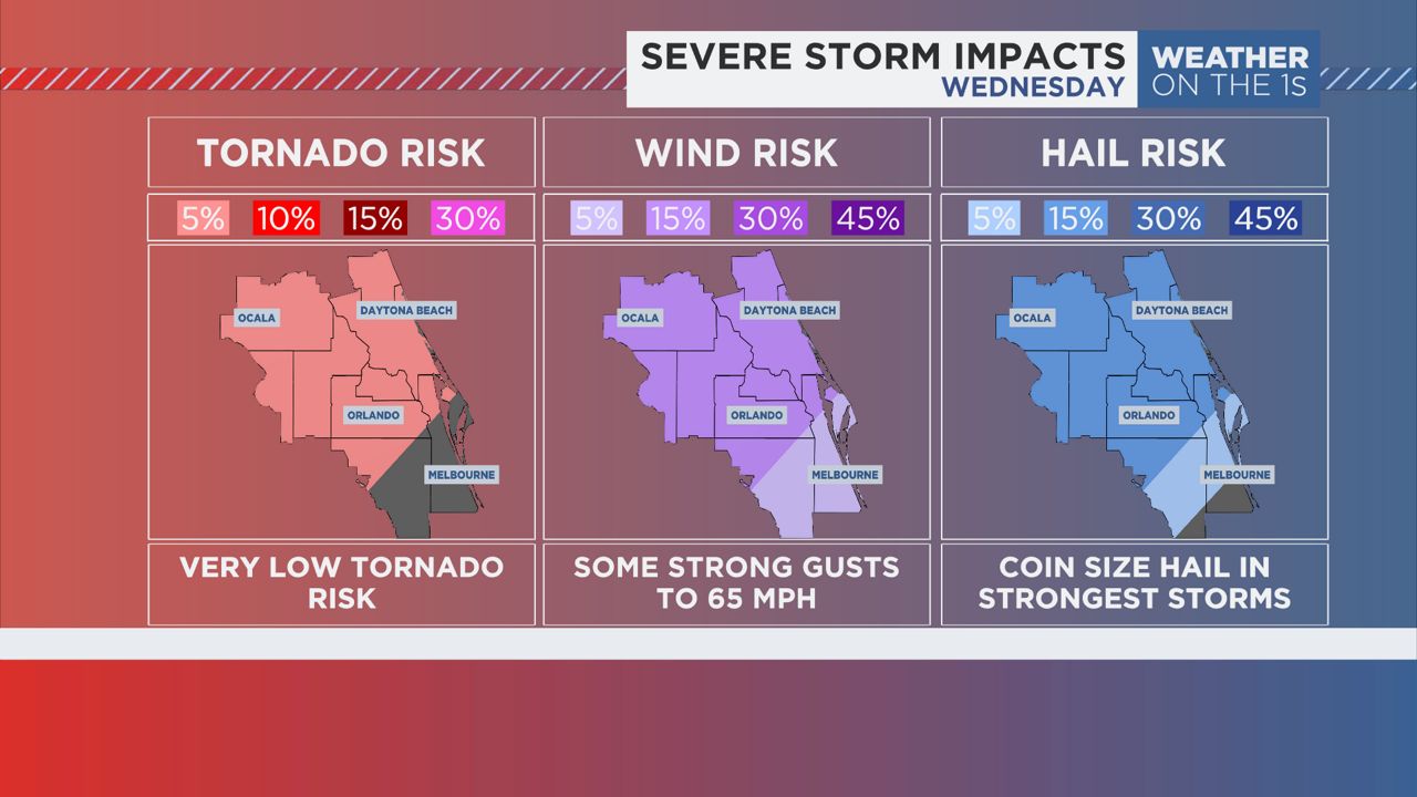
Places like Marion, Sumter and Northern Lake counties will be the first locations to deal with the stronger storms. Most likely between noon and 2 p.m. These are also the counties that will have the best chance of a rotating storm or two capable of a tornado. Besides that, winds could gust up to 65 mph in these areas as the line of storms blast their way through.
The line will continue into Southern Lake, Orange, Seminole, Flagler and Volusia counties between 2 and 5 p.m. This could set up for a gusty, wet and potentially dangerous evening commute across the Interstate 4 corridor. If you plan on being out during these hours, keep an eye on the radar and plan ahead to stay out ahead of the line of strongest storms. It’s possible these locations could see winds gust up to 60 mph and some coin size hail stones. Frequent lightning is also expected.
The line will continue to push east into southern Volusia and much of Brevard and Osceola counties between 5 p.m. and 7 p.m. These areas will likely see some strong winds, although they may sit just below severe parameters. Gusts could range from 50 to nearly 60 mph. A few coin size hail stones could also be likely in the strongest storm or two. Lightning will likely continue, although a steady decrease is likely as the storms push their way into central and southern Brevard county as the line encounters a more stable atmosphere.
Behind this front on Wednesday night, we’ll begin to see a rush of drier air bringing clear skies to area in time for our Thursday morning.
Our team of meteorologists dives deep into the science of weather and breaks down timely weather data and information. To view more weather and climate stories, check out our weather blogs section.