El Niño will almost certainly be the main actor on the winter stage this year. But how big could it get? One prediction is that it could become a “super El Niño.”
In short, El Niño occurs when water near the equator west of South America is warmer than usual for several months in a row. That affects weather patterns over a big part of the world.
The National Center for Atmospheric Research (NCAR) has a new long-range forecast system called SMYLE that produces 20 individual forecasts, and the 20-heads-are-better-than-one is predicting a “super El Niño” this winter.
How big of an El Niño?
To be considered an El Niño, the ocean region where scientists look has to be at least 0.9 degree Fahrenheit above average. In late October, it was about 2.9 degrees above average.
When SMYLE’s 20 forecasts get averaged together, it’s predicting this El Niño will become about 4.3 degrees above average. That’s really warm, and comparable to the historic El Niño events of 1997-98 and 2015-16, according to NCAR.
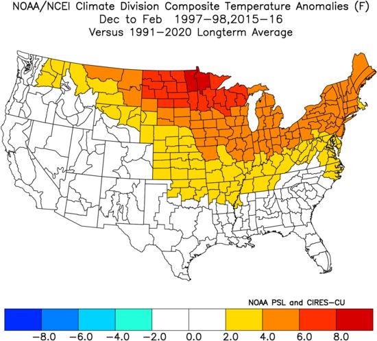
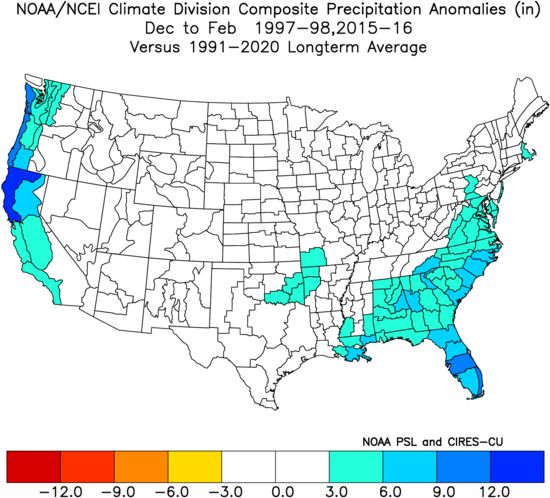
This is how temperatures and precipitation compared to average in those two winters combined. The northern U.S. was mild, while the West Coast and Southeast were wet.
However, that forecast of 4.3 degrees is an average–the model has a range of outcomes among the 20 forecasts. Almost all of them forecast getting at least 3.5 degrees above average, though.
The model also predicted temperature and precipitation trends over the U.S., although NCAR chose not to release that forecast because scientists aren’t as confident in its accuracy.
“While we are able to skillfully predict tropical Pacific sea surface temperature, we are not yet able to confidently make predictions about the atmospheric impacts of those anomalous sea surface temperatures,” says NCAR scientist Stephen Yeager.
How good are these forecasts?
Long-range predictions are tricky, but this isn’t the same as trying to forecast how much rain is going to fall on a particular day, six months from now.
Scientists fed SMYLE historical conditions all the way back to 1970, and then let it make its predictions. It, of course, had no idea what actually happened, but the scientists did. And its forecasts tracked quite well with reality.
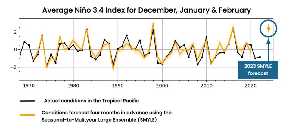
(National Center for Atmospheric Research)
Yeager points out SMYLE predicted a strong El Niño in 1976-1977 that didn’t happen, and sometimes underpredicts weak or moderate anomalies. But, he adds, “our skill at predicting very strong El Niños is very good, but the sample size is small.”
Our team of meteorologists dives deep into the science of weather and breaks down timely weather data and information. To view more weather and climate stories, check out our weather blogs section.