The “Mighty Mississippi” is the second-longest, most powerful river in North America. Its turbulent history involves devastating floods and blistering droughts.
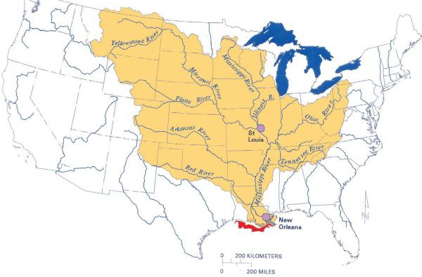
Not only does the Mississippi create borders for 10 states, but it collects water from parts or all of 31 states and two Canadian provinces.
This map of the Mississippi/Atchafalaya River Basin shows major tributaries to the Mississippi River. (U.S. Environmental Protection Agency)
The 2,350 mile long river originates in northern Minnesota as an outlet stream from Lake Itasca. It meanders south, collecting water from hundreds of tributaries, eventually draining into the Gulf of Mexico in southern Louisiana.
The highs
Mississippi River floods can be devastating for entire towns and communities along the river. Of the notable flood events along the Mississippi, “The Great Mississippi Flood of 1927” remains to be to the most destructive river flood in the history of the United States in southern Louisiana.
After months of heavy, persistent rainfall across the Central U.S., extreme runoff from rivers and tributaries swelled up the Mississippi River and water toppled over levee systems.
It inundated 27,000 square miles of land in several states, which led to 246 flood-related deaths and displaced over 700,000 people.
As a result, U.S. Congress passed the Flood Control Act of 1928, which allowed the U.S. Army Corps of Engineers to design and construct new and better ways to control river flooding.
It included improving and expanding the levee system, floodways for excess flow and implementing more dams and reservoirs, pumping plants and auxiliary channels.
Since those improvements after the Flood Control Act of 1928, significant floods along the Mississippi River have been less frequent with less damage and destruction, although Mother Nature can’t be completely tamed.
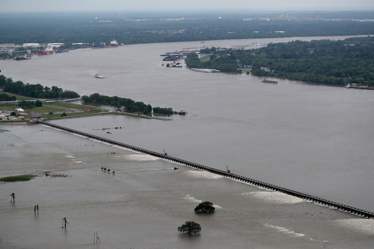
In 2019, workers open bays of the Bonnet Carre Spillway, to divert rising water from the Mississippi River to Lake Pontchartrain, upriver from New Orleans, in Norco, La. (AP Photo/Gerald Herbert, File)
From Dec. 2018 to Aug. 2019, the lower Mississippi River experienced the longest-duration flood on known record, which prompted spillways to be opened up for the first time in years because of excessive rainfall upriver.
Spillways open up to help reduce pressure on levees and prevent worse flooding downstream, as they divert excess water flowing through the river into lakes and reservoirs.
The lows
On the flip side, while drought and low water may not have the same visible effects that flooding along the Mississippi offers, it can also have its own detrimental effects.
Low water levels and a shrinking river can have a devastating impact on the shipping industry. The Mississippi River sees constant barge traffic, eventually ending at the Port of New Orleans toward the mouth of the Mississippi.
According to the Port of New Orleans, 500 million tons of shipped goods travel through each year, making it one of the largest volume ports in the U.S. and a significant player in national trade, imports and exports.
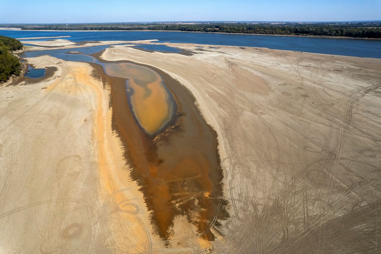
In this photo taken by a drone, the normally wide Mississippi River has been reduced to a narrow trickle Thursday, Oct. 20, 2022, near Portageville, Mo. (AP Photo/Jeff Roberson)
This past October, parts of the Mississippi River and its tributaries shrunk to record low levels because of a lack of rainfall over the summer and worsening drought conditions across the Plains and the Midwest.
The low water levels ground the shipping industry to a halt, limiting traffic through shipping channels. The U.S. Army Corps of Engineers had to dig emergency dredges so barges could continue to travel through the river to ship goods like agricultural products and oil.
According to the U.S. Army Corps of Engineers, to move goods up and down the Mississippi River, a 9-foot shipping channel must be maintained from Baton Rouge, La. to Minneapolis, Minn. South of Baton Rouge, a 45-foot channel is maintained to allow ocean vessels to access ports in the lower Mississippi.
Not only did it create major problems for the shipping industry, but the low water levels also exposed some oddities from underwater, including several shipwrecks.
Around St. Louis, steamboats and ships got exposed that dated as far back as the Civil War, with parts of a wooden gunboat surfacing just 10 feet away from the edge of the Mississippi River.
Not only were multiple shipwrecks exposed, but about two hours south of St. Louis, Tower Rock was exposed enough that allowed people to walk all the way out to the giant limestone rock that usually sits about 60 feet above water level.
Since October, water levels have been steadily rising along the Mississippi River thanks to beneficial rainfall in the Plains and the Midwest.
Our team of meteorologists dives deep into the science of weather and breaks down timely weather data and information. To view more weather and climate stories, check out our weather blogs section.