The remnants of Hurricane Lidia have slid into the northern Gulf of Mexico and will push a line of heavy rainfall and strong storms our way as we head into the back end of our workweek. Here’s everything you need to know regarding the upcoming severe storm threat.
The long advertised late week storm system arrives in Central Florida as we head into the overnight hours Wednesday. Moisture from three separate weather events is set to merge in the northern Gulf of Mexico Wednesday afternoon before sliding its way toward Florida overnight Wednesday into Thursday morning as a new area of low pressure.
While the majority of this moisture comes from what used to be Hurricane Lidia in the Eastern Pacific basin, this is not a tropical system. However, some of the energy left over from Lidia will make its way along with the moisture toward the Sunshine State, setting up the threat for a few strong to severe thunderstorms.
Timing
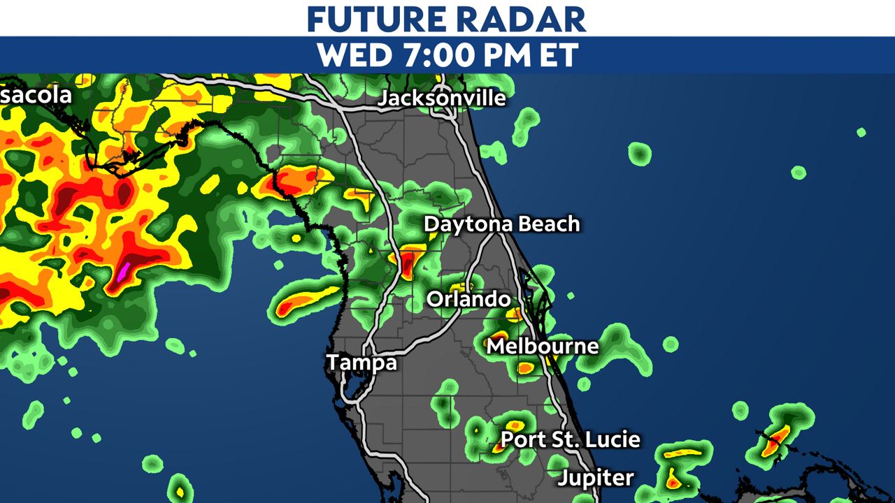
The first few thunderstorms will develop Wednesday evening across much of South and Central Florida. These storms will gradually push north to northeast as a warm front lifts northward across the state. As that occurs, temperatures and dew points will rise. This will help provide the ingredients necessary for a potential strong to severe storm threat into the overnight hours through daybreak Thursday.
Once the warm front lifts northward, warm and muggy temperatures will add ample amounts of storm fuel into the atmosphere. Storm fuel is a key ingredient in keeping storms strong during the overnight hours, as the lack of sunlight tends to keep storms weak. As storm fuel builds across the state through midnight, the atmosphere will be more able to maintain or even strengthen any storms that push ashore from the Gulf Coast overnight.
By midnight, the first round of storms will arrive along the immediate Gulf Coast, bringing heavy rain and frequent lightning along with strong wind gusts there. These storms will push east, arriving in Polk, Sumter and Marion Counties between 1 a.m. and 3 a.m.

The line will progress farther east into the Central Florida metro areas between 3 a.m. and 4 a.m. Thursday morning. Locations like Kissimmee, Orlando, Sanford, Deltona and Deland will likely see the worst weather during this time frame.
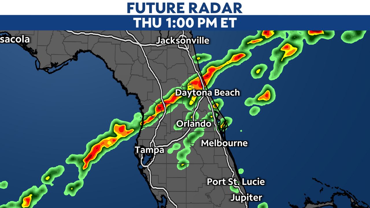
As we progress closer toward daybreak, the line of strong storms will push farther east, heading toward the Atlantic waters. This line of storms will move through places like Flagler, Volusia and Brevard Counties between 5 a.m. and 7 a.m. Thursday.
After the sun rises, a very weak boundary will attempt to slide across the state from the northwest. This boundary will likely be too weak to progress any farther than the I-4 corridor, meaning rounds of rain and storms will likely persist through the late morning into the early afternoon. While sunshine won’t be around on our Thursday, the front hanging north will keep Central Florida in a very warm and muggy airmass, meaning storm fuel will continue to replenish in the atmosphere.
So another round of strong storms is possible between 11 a.m. and 4 p.m. Thursday. This time, the round of storms will be more scattered in nature, resembling more of a typical strong storm sea breeze event rather than an organized batch of passing storms.
Impacts
The Storm Prediction Center has placed all of Central Florida under the risk for a few scattered severe storms overnight Wednesday and throughout the day on our Thursday. For Central Florida, this is the first time this type of severe storm risk has been issued since Aug. 30.
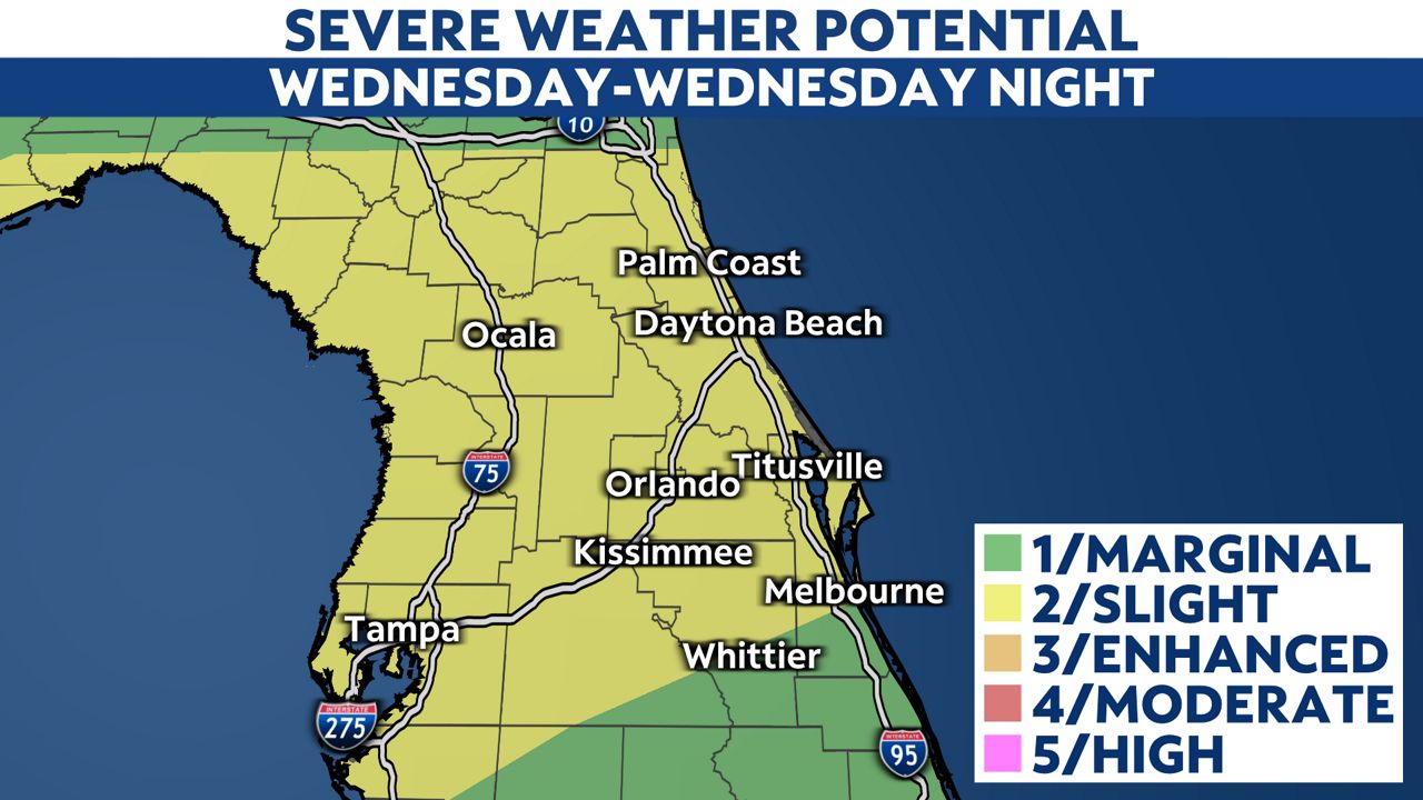
Several impacts are possible with the overnight activity. Heavy rainfall is likely for just about everyone in Central Florida as the line of storms passes by. Rainfall rates of 1 to 2 inches per hour are likely. In rare cases, some locations could see rainfall totals as high as 4 to 5 inches by daybreak tomorrow. While our ground is quite dry and can handle this rainfall, a Flood Advisory or two for the heaviest downpours is possible, especially for those in Orange, Osceola and Brevard Counties.
Gusty winds are expected throughout the night as strengthening southwest flow is anticipated to increase into our Thursday. Wind gusts between 20 and 30 mph are likely, with gusts rising between 50 and 60 mph as the leading edge of the strong storms passes by. These winds are capable of knocking down small tree branches, and causing some minor damage to well built homes like shingle or siding damage. Widespread wind damage is not likely. It would be wise to pick up any lightweight objects by Wednesday evening so they don’t get tossed as winds increase throughout the night into our Thursday.
The threat for a few tornadoes is also evident across Central Florida. While tornadoes with strong storms are always a possibility in Florida, this event will feature a very favorable atmosphere for rotating thunderstorms as the main overnight line passes by. While the possibility for a tornado exists for everyone, those in Polk, Sumter, Marion and central and southern Lake Counties, as well as those farther west toward the Gulf Coast, are the most favored for a brief tornado or two.
Overnight tornadoes are more than twice as deadly as daytime tornadoes because many are sleeping when they occur. Have a way to receive weather alerts tonight. The Spectrum News App is a great resource and we will alert you if a warning is issued for your area. You can download it in your device’s app store for free.

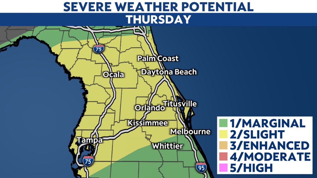
Thursday afternoon’s batch of storms will feature heavy rainfall capable of localized flooding as the main threat. While a few rotating storms are possible, the damaging wind and tornado threat will take a slight step back to the heavy rain and flooding potential for the region. You’ll also want to remain weather-aware throughout your Thursday, especially through the first half of the afternoon.
Our team of meteorologists dives deep into the science of weather and breaks down timely weather data and information. To view more weather and climate stories, check out our weather blogs section.