A gulf low will slide its way east today, bringing a line of showers and thunderstorms to Florida as we go through Tuesday night and into early Wednesday morning.
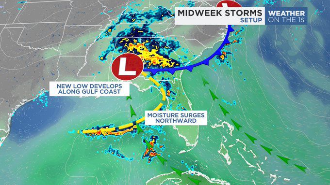
Early Tuesday morning, a new area of low pressure developed along the Gulf coast. This low is tangled up with a small boundary, helping to bring moisture northward from the Gulf of Mexico and Florida straits. This moisture has lead to a large swath of rain and thunderstorms to already develop from the Florida panhandle through the eastern Gulf of Mexico. These storms will make their way east as the afternoon and evening go on.
Afternoon highs in the lower 80s will help to add storm fuel to the atmosphere for any storms that develop across Central Florida this evening. While daytime heating will fade quickly after sunset, the environment will be marginally conducive for a storm or two to tap into it’s full potential, producing a few strong wind gusts, heavy rains, a few strikes of lightning and small hail stones.
Timing and Impacts
There are three main timing aspects with this event.
The first begins between 5 p.m. and 8 p.m. as a few isolated popcorn storms develop across the Florida peninsula. Most of these storms will favor the western half of the Florida peninsula, from the I-75 corridor through Marion, Sumter and Lake counties. These storms will have a small shot of developing into strong storms with gusty winds up to 35 to 40 mph and heavy rainfall. A few lightning strikes may also develop.

The next timing threat begins at 8 p.m. and lasts through 12 a.m. This is when the most likely chance for a strong to severe storm may develop. As storms push into the metro areas of Orange, Seminole and Osceola counties some storms may become strong as they hit an area of greatest instability. Strong winds up to 40 mph, small hail stones equivalent to peas or quarters and frequent lightning is possible with the strongest storm or two. Not everyone will see severe storms, in fact the majority of the region won’t. But we can’t rule out one or two areas that see this type of weather.
After midnight, the storms will push towards the east coast, weakening as they do. The boundary attached to our low will slide past between 2 a.m. and 4 a.m. and while the severe weather threat ends at midnight, the chance for some showers will continue through daybreak. After 7 a.m. the front and associated rainfall should be offshore, with gradually clearing skies through late morning. By lunchtime, partly cloudy skies will give way to mostly sunny skies with a dry afternoon and highs returning into the 80s.
Our team of meteorologists dives deep into the science of weather and breaks down timely weather data and information. To view more weather and climate stories, check out our weather blogs section.