It’s Severe Weather Awareness Week across the state of Florida. Each day this week, Spectrum News will bring you tips you need, in order to face the impacts Florida may bring this spring and summer.
On Wednesday, we’ll focus in on severe thunderstorms and the threats they bring, including strong winds, hail and tornadoes.
Severe weather is a common occurrence in Florida, especially when our wet season kicks in during late spring and summer months.
In order to keep yourself safe from the risks, we’ll discuss how we forecast the threat of severe storms across the Central Florida region.
Understanding terminology
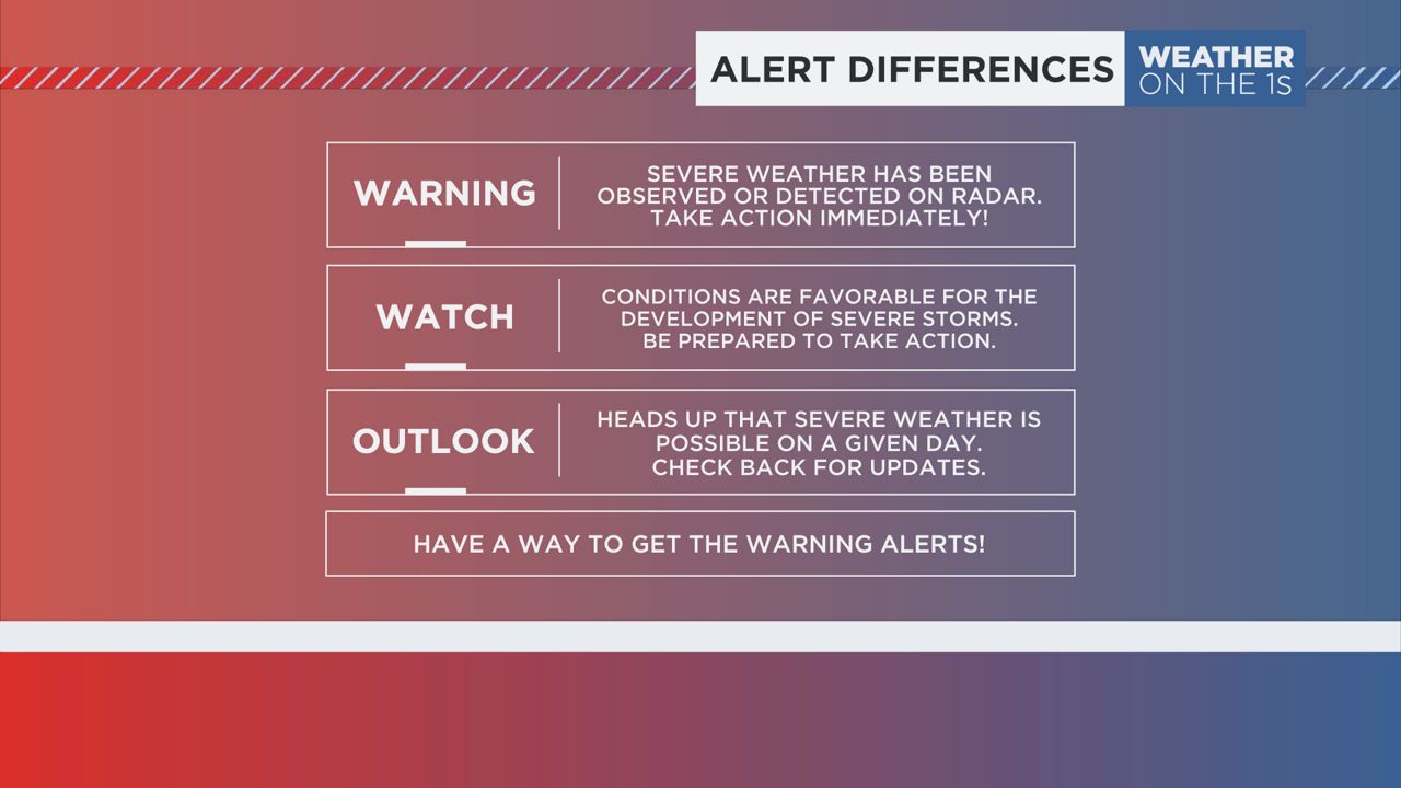
First and foremost, you need to familiarize yourself with three terms: outlook, watch and warning. These terms are key to understanding your risk of severe weather, no matter where you are across the state.
Severe weather outlooks
An outlook is used to provide a heads up that severe storms could be in the forecast on that given date. While outlooks are issued the day of a severe weather event, they can be issued as far as eight days in advance.
Outlooks provide the potential and probability of severe storms within a given area. You’ll want to check back frequently as outlooks change, sometimes two or three times a day.
Even though they can come in a variety of ways, outlooks rank the risk of severe weather from low to high on a scale of 1 to 5. Here’s what each outlook level means:
- Marginal Risk (level 1) – This risk is the most frequent one issued in Florida- and occurs the most nationwide. A marginal risk means that the potential of severe weather is minimal, at best. Some ingredients exist for strong storms to develop, but it’s usually not the best environment for a larger-scale severe weather outbreak. On average, you’ll typically see between one or two severe weather warnings issued in areas where a marginal risk is issued.
- Slight Risk (Level 2) – A slight risk is a step up from marginal, and is issued when the atmosphere is a bit more primed for severe storms to develop. This level of risk is still frequently issued across the state of Florida, especially when potent low pressure systems cross the state in the winter, or during tropical systems. Slight risk days typically bring a tornado risk with them and are capable of producing damaging winds. You’ll usually find at least two to four warnings issued on these days.
- Enhanced Risk (Level 3) – An enhanced risk is issued when numerous severe storms are possible across a region on a given day. These days tend to feature all modes of severe weather, including tornadoes, damaging winds and even large hail. Enhanced risks aren’t too common across Florida, mainly because we lack the large storm systems that are associated with these types of days. However, they have been issued before. The most recent one occurring in April 2023, when very large hail fell all across Central Florida.
- Moderate Risk (Level 4) – A moderate risk of severe weather is the second-highest risk level you can have across the state and usually leads to a severe weather outbreak over an area. These are extremely uncommon across Central Florida, with the last one occurring on Jan. 22, 2017. Areas under this risk level will likely see strong storms generate wind gusts over 60 mph and very large hail. Numerous tornadoes are also possible, which could be strong, ranking as an EF-2 or higher.
- High Risk (Level 5) – At the top of the scale, a high risk of severe weather is the rarest risk level issued nationwide, let alone Florida. In fact, you can go years between one high-risk day before seeing the next. The last high-risk that was issued in Central Florida was back in 2017. These are only issued on days where violent tornadoes or tornado outbreaks are expected to occur. The likelihood of long-distance wind damage events, known as derechos, could also put an area under a high risk.
Watches and warnings
A watch is a term seen most likely on a day where severe weather could develop. When you hear a Severe Thunderstorm Watch or a Tornado Watch has been issued for your area, it indicates that atmospheric conditions are favorable for the development of each, respectively.
Once a watch is issued, severe weather will likely develop within the coming hours. So, take heed if one is issued- they are there to alert you to be ready to take action later on in the day.
Finally, a warning is a term that associated when severe weather is occurring. Unlike a watch, which warns you of the potential of severe storms and/or tornadoes within the coming hours, a warning indicates that severe weather has developed and is happening currently.
Warnings are issued to alert those in the way of a dangerous storm to take action to protect life and property. They can come in several fashions, including Severe Thunderstorm Warnings, Flash Flood Warnings and Tornado Warnings.
The easiest way to describe the differences between watches and warnings is by comparing them to tacos.
Think of it this way – you’re about to make tacos for dinner. You have all the ingredients, but you haven’t assembled a taco yet. This would be your watch phase. You have everything you need to make a taco, you just haven’t made it yet.
The warning phase will occur once you assemble all your ingredients together and actually make your taco.
Severe storm safety
In Central Florida, our severe weather events are largely due to late-day sea breezes during the spring and summer. As boundaries collide, storms can become strong, creating gusty winds, small hail and even brief tornadoes.
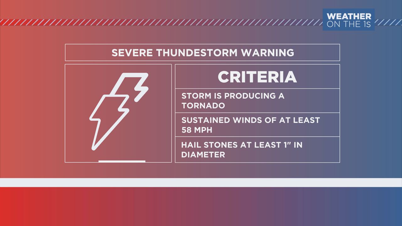
But what makes a thunderstorm severe and how you can prepare before one develops?

If any storm is producing one of those three criteria, it becomes a severe thunderstorm and will get a warning.
If a storm is near that criteria, but doesn’t meet it, a special weather statement may be issued. The purpose for this is to alert the public that an approaching storm nearby could strengthen to severe limits.
If a Severe Thunderstorm Warning is ever issued for your area, follow these tips to keep you and your family safe:
- Seek shelter inside a sturdy structure
- Stay away from doors and windows
- Stay off electrical devices like computers or corded phones
- Stay inside until the storm passes
Tornado safety
If a storm is producing a tornado, or Doppler radar indicates that a tornadic storm is possible in the near term, a Tornado Warning will be issued. In the case you’re under a Tornado Warning, here are some tips to follow:
- Seek shelter on the lower level of a sturdy building or home
- Put as many walls between you and the outside world as possible
- Protect your head with a helmet or other materials around you.
- If in a mobile home, leave and seek a safer shelter
Tornadoes are ranked on a scale from EF-0 to EF-5, with EF-5 being the most damaging. Although tornadoes are typically not confirmed and rated until a day or two after the event takes place.
With that, it is important to treat every Tornado Warning seriously. Here’s the tornado scale with a bit more detail:
- EF-0 Tornado: With estimated winds of 65 to 85 mph, these tornadoes are generally short-lived and produce only minor damage. They can peel off the surface of some roofs, while possibly damaging some gutters or siding. Shallow trees could be knocked over and branches can be broken.
- EF-1 Tornado: With estimated winds of 86 to 110 mph, these tornadoes are a bit stronger and can last for several minutes. These tornadoes are capable of moderate damage and can strip roofs off well-constructed homes. Mobile homes can be overturned or damaged and windows could fail and break.
- EF-2 Tornado: With estimated winds of 111 to 135 mph, these tornadoes are the first that are classified under the “strong” category. Well-constructed homes can find significant damage, including entire roofs being taken off the home. Some foundations may shift on other homes. Mobile homes are likely to be destroyed, while large trees can be completely uprooted.
- EF-3 Tornado: With estimated winds of 136 to 165 mph, these strong tornadoes produce severe damage to a region. Well-constructed homes can be totally destroyed. Cars and trucks can be crushed and trains can be overturned. Trees can be debarked by the winds of these tornadoes.
- EF-4 Tornado: With estimated winds of 166 to 200 mph, these tornadoes produce devastating damage to an area. EF-4 tornadoes are the last tornados on the scale to fall into the “strong tornado” category. Well-constructed homes, businesses and towers can suffer complete damage, while cars can be tossed into the air for several miles. Debris from these tornadoes can become deadly projectiles.
- EF-5 Tornado: With estimated winds in excess of 200 mph, these tornadoes are considered violent and can change the landscape of a region forever. Homes situated in the path of an EF-5 tornado are reduced to concrete slabs. Trees are gone and vehicles, including trucks, are usually reduced to scrap metal. High-rise buildings can find significant structural deformation.
Our team of meteorologists dives deep into the science of weather and breaks down timely weather data and information. To view more weather and climate stories, check out our weather blogs section.

