It’s Severe Weather Awareness Week across Florida and every day this week, Spectrum News is getting you ready and prepared for whatever Florida’s weather may bring this year. Today, we’re talking about the threat of hurricanes and flash flooding and how you can best protect your family and household.
When people think about Florida, the idea of hurricanes may come to the top of their head. In fact, Florida ranks as the number 1 state in the nation for landfall tropical systems, with nearly 40% of all hurricanes on record making landfall somewhere in the state. That stat becomes even more impressive when you realize that roughly 1 in 3 of those storms were major hurricanes of Category 3 strength or higher.
Before we dive into hurricanes and what Floridians can do to protect themselves, you need to understand tropical terminology, words like tropical wave or tropical depression. What do these terms mean and how should you react?
- Tropical cyclone: Any sort of developed tropical system (tropical depression, tropical storm, hurricane)
- Tropical wave: An area of disturbed weather that may develop into a tropical system; does not have a closed circulation
- Tropical depression: An area of disturbed weather that is producing winds of less than 39 mph and has a closed circulation. Typically designated by a number (e.g. Tropical Depression Five)
- Tropical storm: A developed tropical system producing winds between 39 and 73 mph and has a closed circulation. Designated by a name (e.g. Tropical Storm Alex)
- Hurricane: A developed tropical system producing winds of at least 74 mph and is categorized based on wind speed.
- Major hurricane: A hurricane producing winds over 110 mph (Category 3 or higher)
Hurricanes are broken into categories using the Saffir-Simpson Wind Scale. This scale comes from a hurricane’s top estimated sustained wind speed. Below are the five stages of the Saffir-Simpson scale.
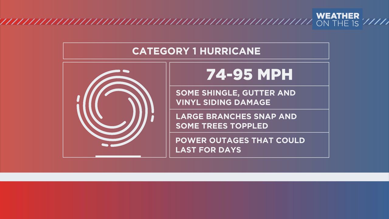
- Category 1 hurricane: Sustained winds 74 to 95 mph
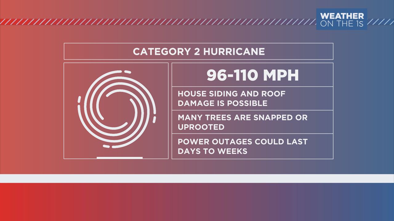
- Category 2 hurricane: Sustained winds 96 to 110 mph
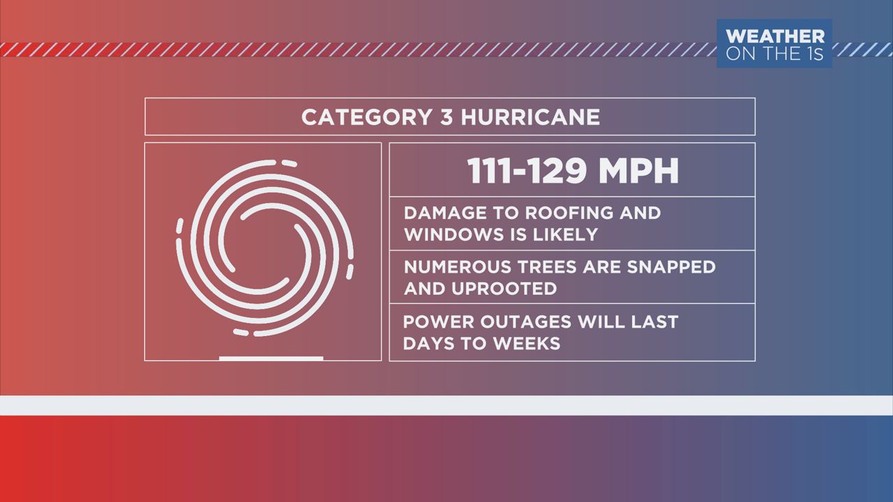
- Category 3 hurricane: Sustained winds 111 to 129 mph
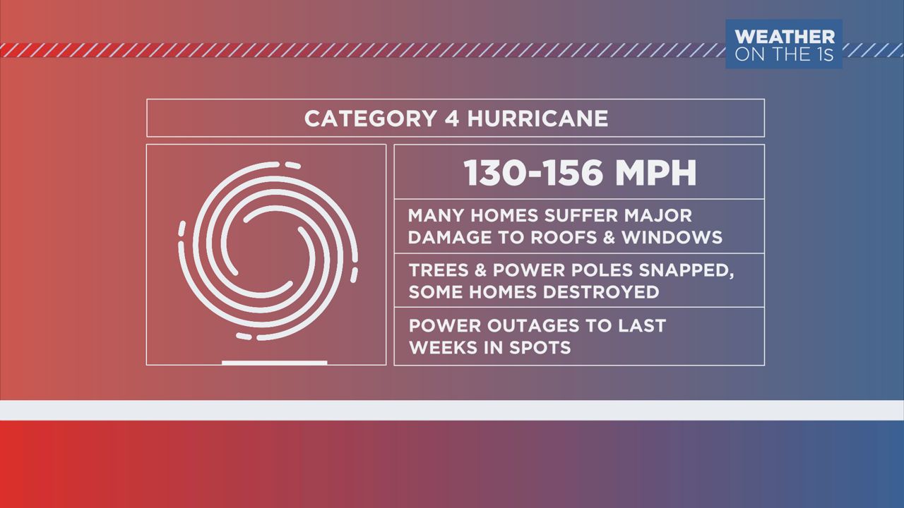
- Category 4 hurricane: Sustained winds 130 to 156 mph
- Category 5 hurricane: Sustained winds 157+ mph
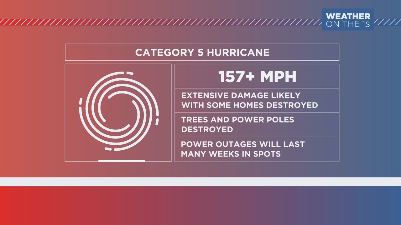
Hurricanes of Category 3 strength or higher are designated “major hurricanes” due to the amount of damage they often cause. These hurricanes can be extremely dangerous to life and property and should be treated with the utmost respect when preparing for a landfall. While you should always adhere to orders given by local and state officials, it’s extremely important to follow those procedures during a major hurricane landfall.
If the Central Florida area ever sees a landfalling storm, you may head a variety of different tropical alerts get issued. Some of the most common include:
- Tropical Storm Watch: Sustained winds of 39 to 73 mph are possible within the area in the next 48 hours. Begin storm preparations immediately.
- Tropical Storm Warning: Sustained winds of 39 to 73 mph are expected within the next 36 hours. Complete storm preparations and take shelter for the rest of the event.
- Hurricane Watch: Sustained winds of 74 mph or greater are possible within the next 48 hours. Begin storm preparations immediately.
- Hurricane Warning: Sustained winds of 74 mph or greater are expected within the next 36 hours. Complete storm preparations and take shelter for the rest of the event.
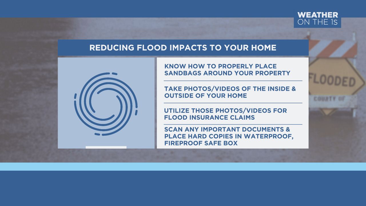
And while hurricane season is still a few months away, it never hurts to begin to figure out what you may need to accomplish before the season arrives. Look at the Spectrum News Hurricane Guide as a great launching point to help you get organized, from what you may need to buy for your hurricane kit, to locations of nearby storm shelters that may open and even a map of local evacuation routes. You can view the guide here.
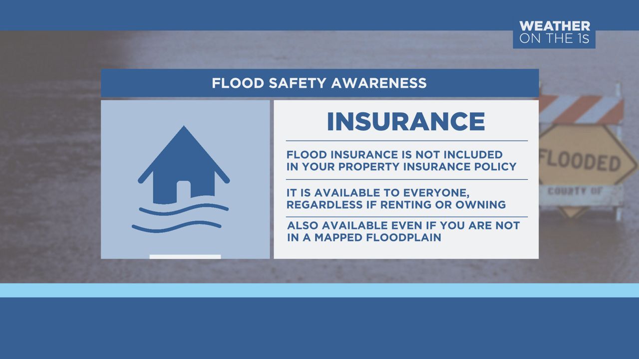
Preforming an insurance checkup on your property during the offseason is a great idea, as well. Remember, homeowner policies do not come with flood insurance. If you think that flood insurance may be a smart move for you or your property, consider investing in some before the season begins. It takes at least one full month for changes or additions to insurance policies to take effect. Don’t wait for a storm to be heading your way; do these ahead of time so you’ll be ready when the season starts.
Besides hurricanes, flooding is also a major concern across Central Florida, especially during our wet season. Last year, Fort Lauderdale saw over 100 inches of rainfall, which caused flooding all across the South Florida area. Much of that rainfall came from daily seabreeze storms, and while uncommon for Florida to see that much, it’s possible Central Florida could come close to that total any given year with the right conditions.
When flooding threatens your neighborhood, a flood alert could be issued. Here’s what they mean:
- Flood Watch: Conditions are favorable for flooding to occur in your area.
- Flood Advisory: A rainfall event is occurring that may trigger significant inconvenience for low-lying or poor drainage areas.
- Flood Warning: Flooding is imminent or already occurring, mainly around waterways. Seek higher ground.
- Flash Flood Warning: A sudden flash flood is imminent or occurring. Seek higher ground.
- Flash Flood Emergency: A life-threatening flash flood is occurring, leading roadway washouts and other significant dangers. Seek higher ground. Call 911 if needed.
What happens if you come upon flooding while driving? First and foremost, do not drive through it. Even if you think a flooded roadway isn’t deep, it’s possible that the flooding has weakened the road enough for it to break away under the flood waters. Always find an alternate route around the flooding and never drive through it. And if a road is barricaded, do not drive around the barricades. Remember: Turn around, don’t drown!
Our team of meteorologists dives deep into the science of weather and breaks down timely weather data and information. To view more weather and climate stories, check out our weather blogs section.