The National Hurricane Center issued its final report on Idalia Tuesday.
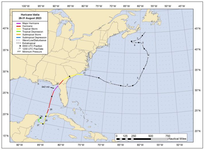
Idalia originated in the eastern Pacific Ocean on Aug. 23, 2023. It eventually crossed over Central America and moved into the Caribbean, becoming a tropical depression in the Yucatan Channel on Aug. 26.
Later that night, it made landfall in Cozumel as it slowly meandered southwest.
It slowly moved around the Yucatan Channel before finally pulling north and passing west of Cuba on the evening of Aug. 28.
It became a hurricane shortly after midnight local time that night.
The eye of Idalia passed 110 nautical miles west of Tampa on the evening of Aug. 29, becoming a major hurricane out in the Gulf after midnight.
Idalia briefly reached Category 4 status, then weakened rapidly as it was making landfall.
It made landfall as a Category 3 storm near Keaton Beach with winds of 100 knots at 6:45 a.m. on Aug. 30.
Idalia continued to weaken rapidly over land, becoming an extra-tropical cyclone after it passed over North Carolina on Aug. 31.
Idalia’s track. (NOAA)
Storm surge
Storm surge was the most widespread impact of Idalia along the coast, with 8 to 12 feet of surge above ground level from Keaton Beach to Steinhatchee.
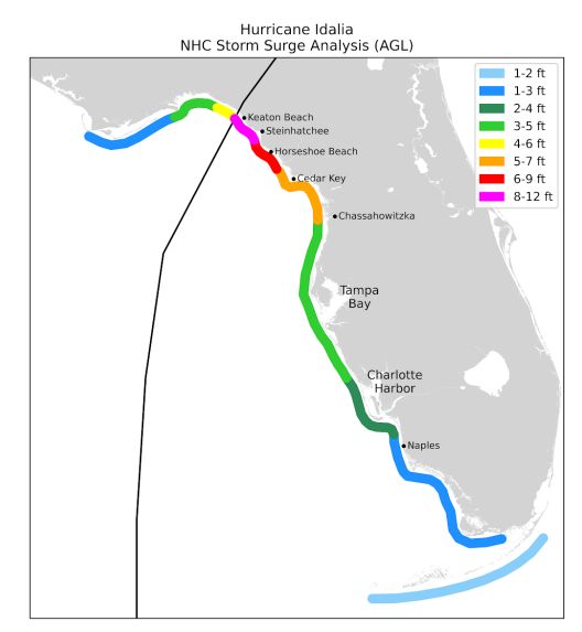
Hurricane Idalia maximum storm surge. (National Hurricane Center)
Surge above ground level was 6 to 9 feet from Steinhatchee to the Suwannee River, 5 to 7 feet between the Suwannee River and Chassahowitzka, and 3 to 5 feet between Chassahowitzka and Englewood.
A record surge of 8.04 feet above ground level was observed in the Steinhatchee River, two miles upstream from the Gulf of Mexico.
Tampa Bay’s surge was 5.7 feet above the predicted tide which yielded water levels 4.56 ft above ground level.
Total damage from Idalia was estimated to be $3.6 billion, with most of it occurring in the Big Bend of Florida.
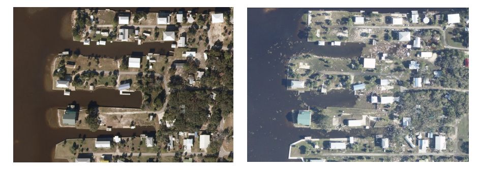
Horseshoe Beach before and after Idalia. (NOAA)
Wind and rain
Before landfall, Idalia reached a minimum pressure of 942 mb with estimated winds of 116 knots or 133 mph, then weakening to 100 knots at landfall or 115 mph.
The highest observed sustained wind was 64 knots in Horseshoe Beach or 74 mph.
The highest observed wind gust was 74 knots or 85 mph in Perry, Fla.
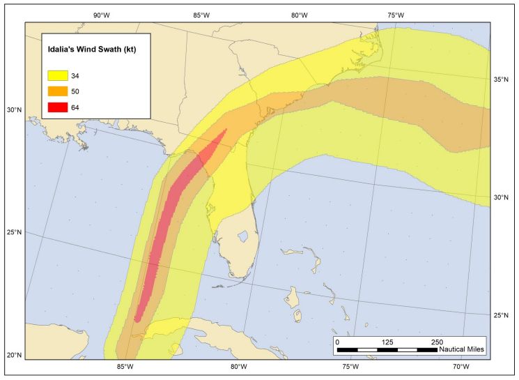
Wind swath from Idalia. Hurricane force wind swath in red. (NOAA)
On the ground observations were limited near the landfall site of Idalia as the Big Bend of Florida is a very rural area.
Idalia brought widespread rainfall totals of 5 to 7 inches from the Big Bend of Florida to North Carolina.
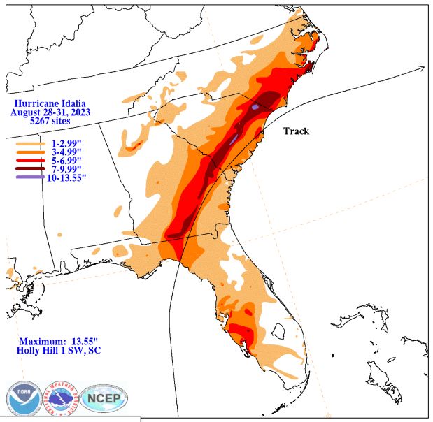
Rainfall from Idalia. (NOAA)
Some pockets of 7 to 10 inches were observed.
Casualties
Idalia was responsible for 12 deaths, 8 of them were direct.
One man in Brevard County died while windsurfing during the storm. Seven other lives were claimed by rough surf from the storm.
Of the four indirect deaths, two were caused by falling trees during cleanup in Georgia and two died in car crashes in Florida.
Our team of meteorologists dives deep into the science of weather and breaks down timely weather data and information. To view more weather and climate stories, check out our weather blogs section.