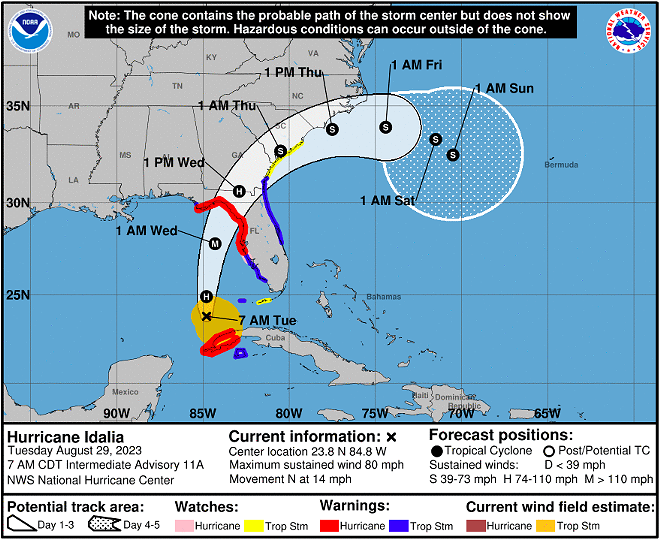
Idalia strengthened into a Category 1 hurricane overnight, and is on track to make landfall along Florida’s Gulf coast as a dangerous major storm early Wednesday morning.
According to the National Hurricane Center’s 5 a.m. report, Idalia’s track bumped slightly west, but is still on target to make landfall just north of Tampa Bay, heading inland between Tallahassee and Gainesville.
“The new forecast is similar to the previous one, and confidence is increasing in an extremely dangerous major hurricane making landfall Wednesday along the west coast or Big Bend region of Florida” said the report.
As of now, Idalia is about 360 miles south of Tampa Bay, traveling north at about 14 mph with sustained winds of 75 mph.
However, forecasters say Idalia will speed up and grow in strength throughout the day, eventually becoming a possible Category 3 storm before reaching Florida Wednesday. Forecasters predict the hurricane will reach peak sustained winds of 120 mph with gusts up to 150 mph and storm surge that could surpass 12 feet.
Most of Florida’s West coast is under a hurricane and storm surge warning. As of Tuesday morning, Central Florida is not predicted to face the brunt of the storm. Sumter County is under a hurricane warning while Orange, Osceola, Brevard, Lake, Polk, Seminole and Volusia counties are all under a tropical storm warning.
8/29 5AM Update | #Idalia has strengthened into a hurricane 85 miles north of the western tip of Cuba. There have been no changes to the previous Tropical Storm Warnings. Gusty squalls will begin to enter the area this afternoon, increasing in frequency and intensity into tonight pic.twitter.com/Hkt6EO4OYR
— NWS Melbourne (@NWSMelbourne) August 29, 2023
The National Weather Service Forecast Office in Melbourne predicts parts of east Central Florida will see 2-3 inches of rain, with some pockets hitting 4-5 inches. The center warns tornadoes could begin to form inland starting Tuesday afternoon and continue into Wednesday.
“With an inner core now present, the stage is set for Idalia to rapidly intensify before landfall. Shear should continue to lower over the cyclone as an upper-level trough departs the northeastern Gulf of Mexico and ridging builds closer to the cyclone,” continued the report. “These changes, combined with extremely warm and deep waters the hurricane will be traversing, all strongly point to rapid intensification.”
Orlando Weekly will keep an updated list of local shelters, sandbag locations and closures.
Subscribe to Orlando Weekly newsletters.
Follow us: Apple News | Google News | NewsBreak | Reddit | Instagram | Facebook | Twitter | Or sign up for our RSS Feed