Have you ever dreamt of flying into a hurricane? That is what a brave group of scientists known as the “Hurricane Hunters” get to do for a living.
Most pilots try their best to avoid flying into storms and severe weather, but the Hurricane Hunters fly straight toward the strongest storms on earth.
Even though modern satellite technology has revolutionized weather forecasting and our understanding of hurricanes, there are still limitations.
Since satellites can’t measure barometric pressure or accurate wind speed information, the Hurricane Hunters help fill in the gaps with crucial data to improve forecasts.
According to the National Hurricane Center (NHC), data collected by the Hurricane Hunters increases the accuracy of hurricane predictions and warnings by as much as 30%.
There are two branches of the Hurricane Hunters. NOAA operates one, and the other, by the United States Air Force.
NOAA’s Hurricane Hunters primarily focus on research and reconnaissance missions within storms, and the main fleet comprises three aircraft: two WP-3D Orion aircraft and one Gulfstream IV jet.
The U.S. Air Force Reserve operates the 53rd Weather Reconnaissance Squadron, the other group of Hurricane Hunters. They focus on weather reconnaissance missions and their fleet consists of 10 WC-130J aircraft.
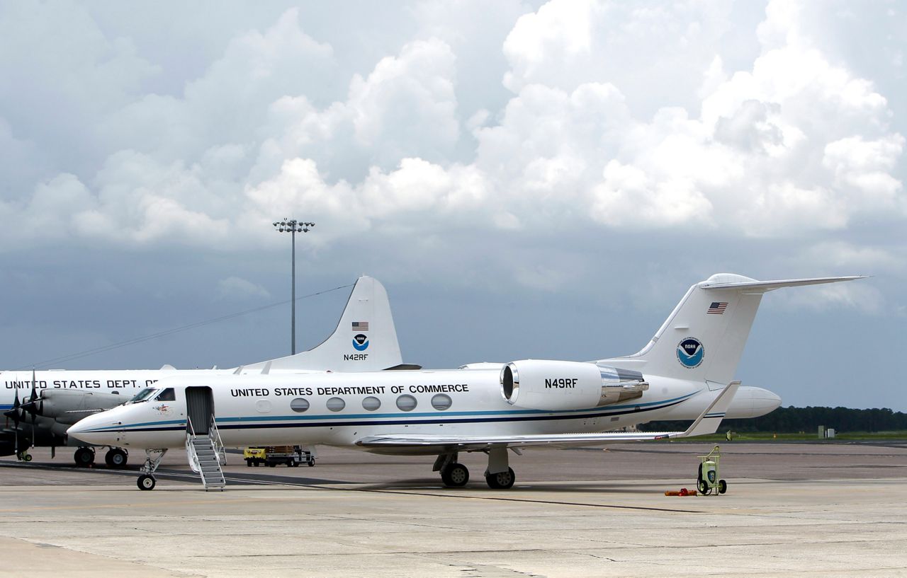
Gulfstream IV (Gonzo)
The Gulfstream IV (Gonzo) is a jet designed to fly at high altitudes above, around and in front of storms. Not only does it fly above tropical storms and hurricanes, but it also does research in and around winter storms, as well.
Gonzo has a ceiling of about 45,000 feet and provides observational coverage critical for weather systems in the upper atmosphere.
A Hurricane Hunter Gulfstream IV-SP (G-IV) aircraft, warms up its engines before takeoff from MacDill Air Force Base in Tampa, Fla., Tuesday, Aug. 23, 2011. The crew of the aircraft fly to the eye of hurricanes and gather data. (AP Photo/John Raoux)
As Gonzo soars in the upper atmosphere, it drops a tube-shaped instrument from the bottom of the aircraft called a GPS dropsonde. As the instrument falls from the aircraft, it measures pressure, temperature, humidity and GPS Doppler frequency shifts and sends it back to the aircraft.
The GPS Doppler shifts can help determine horizontal and vertical wind components. Once the crew onboard receives the data from the dropsonde, a flight director checks it and sends that information to the National Centers of Environmental Prediction (NCEP) and the National Hurricane Center (NHC).
Gonzo collects useful data that gets fed into models and plays a critical role in track forecasts, as it helps determine the surrounding atmosphere and the environment that a storm is moving toward.
Just recently, congress passed the Inflation Reduction Act in the summer of 2022, which included nearly half a billion dollars for weather forecasting and research. Included in that money is the funds for a new Gulfstream IV, which should become operational by the 2024 hurricane season.
WP-3D (Miss Piggy and Kermit)
NOAA has two Lockheed WP-3D Orion aircraft, “Miss Piggy and Kermit.” These are planes responsible for flying directly into, and through storms at lower altitudes, usually between 8,000 to 10,000 feet above the water.
These large aircraft can tolerate extreme amounts of turbulence and strong winds.
Not only do they perform research and collect data inside of hurricane across the Atlantic basin, but these planes and their crew have supported tropical research in the eastern Pacific Ocean, and even parts of the Arctic Ocean and Alaska.
NOAA also deploys the WP-3D’s to monitor and study severe storms, the quality of the atmosphere, oceanographic conditions and climate trends.
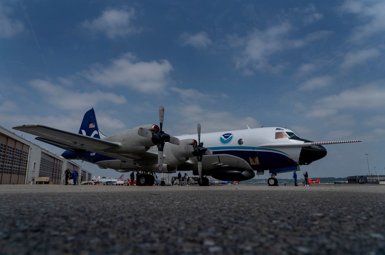
National Oceanic and Atmospheric Administration’s WP-3D Orion hurricane hunter aircraft stands on the tarmac at Washington National Airport, Arlington, Va., Tuesday, May 3, 2022. (AP Photo/Gemunu Amarasinghe)
NOAA has eqipped these aircraft with three radar systems and collect data to fill in gaps that aren’t available from ground-based radar or satellite imagery.
Having multiple radars allows the planes to scan the storm vertically and horizontally while flying through, giving researchers and forecasters an in-depth look at all the layers and structure of a storm.
While in and around the storms, crewmembers deploy expendable probes that collect data while they parachute to sea, similar to the GPS dropsondes from the Gulfstream IV. The probes transmit pressure, temperature, humidity, wind speed and direction back to the aircraft.
Another critical tool on these aircraft to forecasters at the NHC are the Step Frequency Microwave Radiometers (SFMRs).
SFMRs sense wind speed at the surface of the ocean from seafoam that is created by high winds at the surface, providing NHC with the most accurate data in real-time.
Think you can fly with the Hurricane Hunters? Here is a video from Nick Underwood, a NOAA Hurricane Hunter on-board “Kermit” as the crew flew through Hurricane Ian before making landfall on Wednesday, Sept. 28, 2022.
What’s next for NOAA? During Hurricane Ian, NOAA deployed a 27-pound drone into the eye of the Category 4 storm before making landfall for the first time.
The new Altius-600 drone is an unmanned aircraft system (UAS) that was developed to operate in low and medium-altitude maritime environments that are too dangerous for humans to go. It has a range of 275 miles and can travel up to 100 mph with an airframe designed to handle considerable damage.
During Hurricane Ian, the Altius-600 drone had a successful two-hour mission around the eye and eyewall, recording winds aloft as high as 216 mph, and descending as low as 200 feet at one point.
This new drone technology will allow NHC and NCEP to receive even more critical data within a storm and help improve future forecasts. The video below is from a test flight in June 2022 of Altius-600 being released from NOAA’s WP-3D Orion aircraft.
WC-130J
Unlike the previous two aircraft which are operated by NOAA, the U.S. Air Force Reserve Command operates the WC-130J. Also known as Hurricane Hunters, the government has named the flying unit responsible for these 10 planes the 53rd Weather Reconnaissance Squadron.
The WC-130J is another large aircraft that was built to penetrate and withstand the world’s most powerful storms at lower altitudes, typically around 10,000 feet.
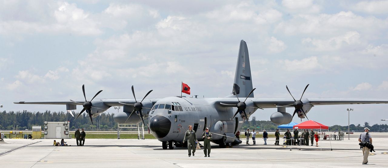
In this photo taken Friday, May 12, 2017, a USAF Reserve, WC-130J hurricane hunter aircraft is shown at the U.S. Coast Guard Air Station Miami, as reporters and guests take a first hand tour of the aircraft, at the Miami-Opa Locka Executive Airport, in Opa-locka, Fla. (AP Photo/Alan Diaz)
Similar to NOAA Hurricane Hunters, the 53rd Weather Reconnaissance Squadron provides surveillance of tropical systems across both the Atlantic and Pacific basin, and flies winter missions off both coasts of the U.S. to support analysis and predictions of winter storm events.
The WC-130J also drops GPS dropsondes in and around storms, which measure pressure, temperature, humidity and wind data.
Crews equipped all 10 WC-130Js with SFMRs back in 2007 and 2008, responsible for continuously measuring surface winds and rainfall rates below the aircraft.
Just like data collected from the NOAA Hurricane Hunter missions, the squadron collects its data and then sends it back to NCEP and NHC to get fed into weather forecasting models and improve forecasts.
So, next time you see a forecast cone from the National Hurricane Center, you can thank the Hurricane Hunters for providing valuable data which makes it all possible. And next time you’re on a plane, you can be thankful it’s not going into the eye of a hurricane.
Our team of meteorologists dives deep into the science of weather and breaks down timely weather data and information. To view more weather and climate stories, check out our weather blogs section.