As winter progresses across the Northern Hemisphere, cold outbreaks are becoming more common. And for many across the nation, the coldest day of the year is likely on the way to your city.
As we move deeper into the heart of winter, the coldest part of the year is upon us across the Midwest and Northeast. Back in 2022, the National Oceanic and Atmospheric Administration released an interactive map that details when the coldest day of the year is for your city.
In the analysis conducted by NOAA’s National Center for Environmental Information (NCEI), climate experts found that this chilly milestone is now happening later than it used to.
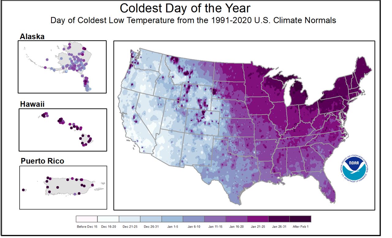
Check out the map below. It reveals when, on average, the coldest day of the year hits based on data from 1991 to 2020. From the Mississippi Valley to the East Coast, temperatures hit rock bottom around mid-to-late January.
According to their report, the study found several interesting regional differences across the nation. But the most notable observation was the separation between dates the Rocky Mountains bring forth.
That’s because temperatures out west of the Rockies are largely influenced by the parade of storm systems moving ashore from the Pacific Ocean. These storm systems determine the temperature influences, and thus temperatures more closely align with the seasonal solar cycle if you live west of the Rocky Mountains.
While a few pockets out west have seen their date for the coldest day of the year slide later into the season, these locations are typically found in deep valleys, where calm winds and the bountiful snow cover can cause a temperature inversion—where the temperature at the surface is colder than the temperature above the ground.
But for those located east of the Rockies, the analysis found that the date for the coldest day of the year has slid later into the season.
While the West largely finds their temperature fluctuations based on storm systems, the eastern U.S. finds their temperature regime largely dictated by modified snow cover to the north.
Believe it or not, snowfall in Canada drives the temperature forecast for the eastern half of the country. That’s because as snow falls and blankets the ground in Canada, that snowfall at the surface helps cool temperatures.
As Canada’s snow cover grows, it reflects more and more solar radiation away from the ground and back out to space, keeping temperatures colder than they could be.
As storm systems develop and move eastward across Canada, the wind flow can then push this colder air mass at the surface southward into the United States. This is what’s responsible for those cold air outbreaks across the northern tier of the country.
Now, keep in mind, these dates are calculated by averaging temperatures over a 30-year period, from 1991 to 2020. The actual coldest day may happen in your area earlier or later than what the map above suggests.
NOAA’s analysis points out an interesting shift, however: Compared to climatological averages from 1981 to 2010, the coldest day is now occurring three to six days later or more in many places east of the Rockies.
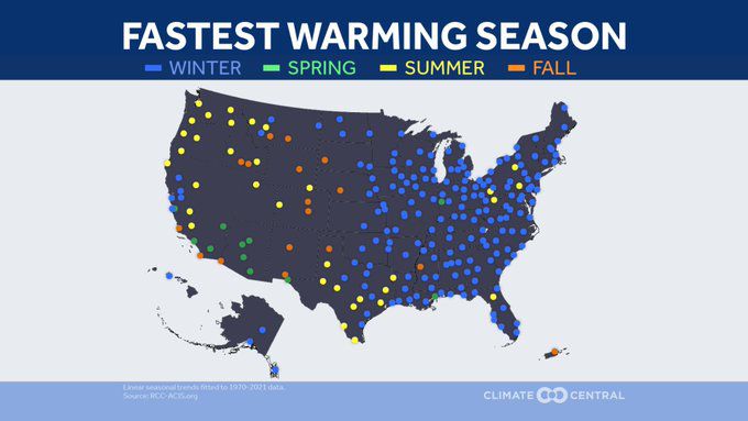
The newer 30-year averages ending in 2020 also show more warming early in the winter in the eastern U.S., according to NOAA. This lines up with findings from Climate Central, which revealed that winters in the United States are warming faster than any other season east of the Rockies and in Alaska.
Our team of meteorologists dives deep into the science of weather and breaks down timely weather data and information. To view more weather and climate stories, check out our weather blogs section.