Image courtesy the National Hurricane Center
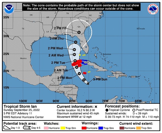
Latest project path for Tropical Storm Ian as of Sunday afternoon
The National Hurricane Center on late Sunday afternoon released a new model for Tropical Storm Ian’s projected track, nudging it slightly back eastward which means potentially more of an impact throughout Florida.
The 5 p.m. Sunday update shifted the forecast cone for Tropical Storm Ian a little back eastward, which means that Central Florida might be feeling more of the impacts of Ian as it moves towards and possibly through Florida late this week.
Tropical Storm Ian’s move through Florida looks to now happen towards the latter part of the week instead of midweek, as Saturday’s forecast posited. The storm will more than likely to “be at or near major hurricane strength” as it passes over western Cuba on late Monday into Tuesday.
From there, Ian moves into the Gulf of Mexico midweek where it will stay at hurricane-strength. After that, models are still somewhat uncertain as to the storm’s path through or near Florida.
Ian is now expected to move towards Florida’s western coast late Wednesday and into Thursday. As of this writing, it looks as though the Keys and the Panhandle will experience severe weather from Tropical Storm Ian. In particular, “heavy rainfall may affect North Florida, the Florida Panhandle and the Southeast Thursday, Friday and Saturday.”
Florida is still under a state of emergency and here in Orange County, we are in a holding pattern. Orange County Public Schools will be in session on Monday and Tuesday, with a decision made about the rest of the week to come. Local officials in Orange County urge residents to be prepared with supplies and have opened several sandbag-filling sites.