During a busy severe weather season, it’s easy to recognize the intense thunderstorms that we often track on radar. But when we look for high winds and tornadoes, we flip the radar into velocity mode and focus on two primary colors: red and green.
What You Need To Know
- Velocity mode can show wind and movement in a storm
- Green areas show wind blowing toward the radar; red means away
- Those colors up against each other strongly suggest circulation
- Velocity mode can also track straight-line wind
Our radars can be put into a few different modes to detect different things. For example, on a bright, sunny day, the radar is flipped to clear air mode, which can detect small particles close to the radar site. Sometimes this can pick up bugs, birds and even dirt. It can also detect plumes of smoke from large fires.
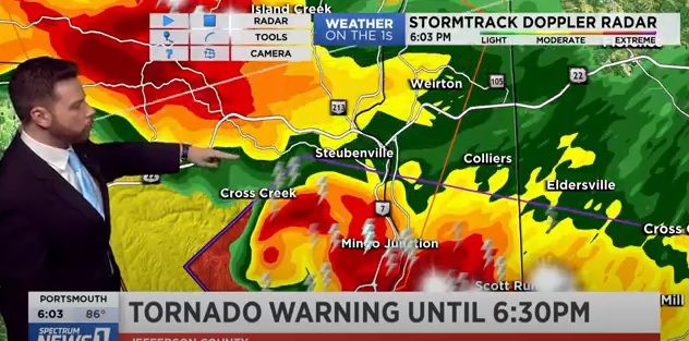
Precipitation mode
The most common mode that a radar is on is the precipitation mode. This is what we use to show anything from spotty showers to full-blown severe thunderstorms.
It will take between 15 and 20 seconds for the radar beam to make a full sweep across the sky. The beam scans the size of the particles in the air, hits them, then sends them back to the radar site, where that information is converted to an image.
Lighter shades of green represent showers and light rain, while oranges and reds often depict torrential downpours and severe thunderstorms.
Velocity mode
In velocity mode, the radar is detecting motion both toward and away from the radar site. In this case, the strength or intensity of the precipitation isn’t shown. Precipitation moving toward the radar is displayed on the map in greens, while movement away from the radar is portrayed in reds.
There’s even a “storm-relative” velocity mode. This subtracts the average speed and direction of the storm, which can give us a better sense of an individual storm’s actual rotation.
When we zoom in on different colors, we can get a sense of how strong winds are within, ahead of and behind storms.
It’s important to remember that surface winds are only for areas close to the radar site. The radar is always tilted up, so the farther you move away from the radar, the higher up in the sky the beam goes.
Circulation and damaging wind
Oftentimes during severe weather coverage, the meteorologist will put the radar in velocity mode and look for “winds up against each other.” When the greens form a tight bond with the reds, circulation is present. You can see that in the example below.
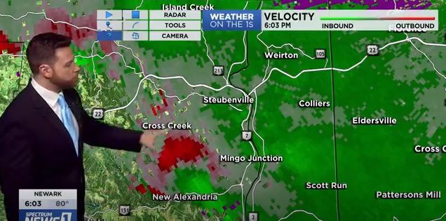
When we observe this, we note the location of the center of the circulation and then switch back to precipitation mode. As meteorologists, we ask ourselves “does the area match up to where a severe storm is?” and “can we identify a hook echo or other tight area of circulation on the radar that would also indicate a tornado?”
Many times, while we track severe weather with these observations, we’ll be in contact with emergency management, storm chasers and observers on the ground who can visually confirm a tornado or funnel cloud. Rotation on radar doesn’t guarantee a tornado is happening, but it’s a tool to know one is possible. Straight-line winds can also be detected using velocity.
Next time you see us tracking storms, look for the switch from precipitation mode to velocity mode and see if you can spot circulation and rotation along with us!