Bright and beautiful conditions are in the forecast for much of the Northeast on Saturday, but that wasn’t the case 10 years ago when one of the strongest storms to hit the Northeast moved onshore: Superstorm Sandy.
Along with redefining the coast, the devastation brought on by Sandy was unimaginable, particularly for those living in New York and New Jersey.
The 2012 Atlantic hurricane season was an active one, totaling in 19 named storms- 10 of which became hurricanes. While Sandy was the tenth and final hurricane, it was also the deadliest and costliest storm of the season (and the fourth costliest storm to hit the U.S.).
Sandy’s history
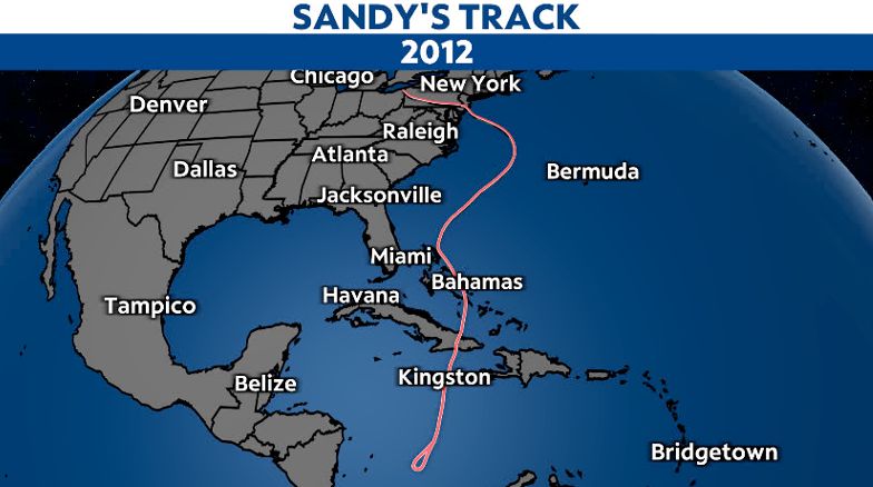
Sandy originated in the Caribbean Sea, on Oct. 22, 2012, becoming the eighteenth named storm of the season. As it headed north, it became a Category 1 hurricane two days later prior to making its first landfall over the southeastern coast of Jamaica.
Despite its brief interaction with land, Sandy rapidly intensified once it moved north of Jamaica. Less than 24 hours later, it became a major Category 3 hurricane just before making its second landfall near Santiago de Cuba.
This time, Sandy did weaken upon emerging back off shore and continued to do so as it weaved its way through the Turks and Caicos Islands and the Bahamas.
It briefly became a tropical storm just north of the Bahamas on the evening of Oct. 25, but regained its hurricane status again roughly 12 hours later as it curved toward the northeast.
Even though the center of Sandy stayed well off the Southeast coast, the storm also nearly doubled in sized, bringing impacts to the Carolinas and Virginia. It continued to head toward the northeast before making its signature turn toward the northwest late on Oct. 28, making a beeline toward the Mid-Atlantic coast.
The notable “blocking pattern”, with high pressure to the north and an upper-level low to the west, essentially forced Sandy to change trajectories.
At the same time, it also promoted further intensify, allowing Sandy to become a Category 2 hurricane well east of Virginia Beach on the morning of Oct. 29. Although it weakened back to a Category 1 hurricane six hours later.
Sandy turned into a post-tropical cyclone just hours before making landfall over Brigantine, New Jersey on the evening of Oct. 29. Yet, it still brought catastrophic impacts along the Jersey Shore and the New York metro area, especially in regards to storm surge and significant flooding.
A closer look at the numbers
Even though Sandy never exceeded a Category 3 strength, it was one of the largest hurricanes in the Atlantic Basin, with a diameter reaching a total width of 1380 kilometers (over 850 miles).
It accounted for a total of 147 deaths, with nearly half occurring in the Mid-Atlantic and Northeast alone.
Along with bringing tropical storm and hurricane conditions to the Caribbean, it also affected 24 states in the U.S., with impacts ranging from widespread tropical storm and hurricane-force winds to life-threatening storm surge and other significant coastal implications.
While Sandy was not the strongest hurricane to hit the U.S., its timing was impeccable, making landfall right during the astronomical high tide. In addition, the Jersey Shore beaches north of Brigantine, as well as New York Harbor, were also on the dirty side of the storm, which exacerbated flooding and storm surge-related impacts for those areas.
Winds
Sandy produced its strongest winds while it was a Category 3 hurricane near Cuba, with maximum sustained wind speeds reaching 115 mph. Even though wind speeds were not at that magnitude upon making landfall along the Mid-Atlantic coast, Sandy’s wind field nearly doubled.
Check out this intriguing wind field animation achieved by the National Hurricane Center (NHC) here.
As it approached the Jersey Shore, tropical storm-force winds gusting between 40 to 70 mph were observed throughout the Mid-Atlantic and southern New England. But even higher gusts were reported near and along the coasts of New Jersey and New York.
At landfall, reported wind gusts near Brigantine, New Jersey were around 80 mph. Yet, a gust of 91 mph was reported in Sea Heights, New Jersey.
Hurricane-force winds also battered New York City and Long Island, where gusts measured over 75 mph. Although the highest gusts hit 90 mph near Tompkinsville, Staten Island and Islip Airport out on Long Island.
Strong winds paired with saturated or flooded grounds led to widespread power outages that lasted weeks, and even months for some of the hardest hit places along the New York and New Jersey Beaches.
Nearly three million were without power in New York and Long Island, with power outages affecting over two million in New Jersey.
Rainfall
While powerful winds and storm surge devastated the Jersey Shore and New York metro area, most of the heavy rain stayed on the southern side of the storm, primarily impacting the Delmarva and southern tip of New Jersey.
In particular, the greatest rainfall totals reached near and even over a foot across eastern Maryland and Delaware. The highest added up to 12.6 inches in Bellevue, Maryland.
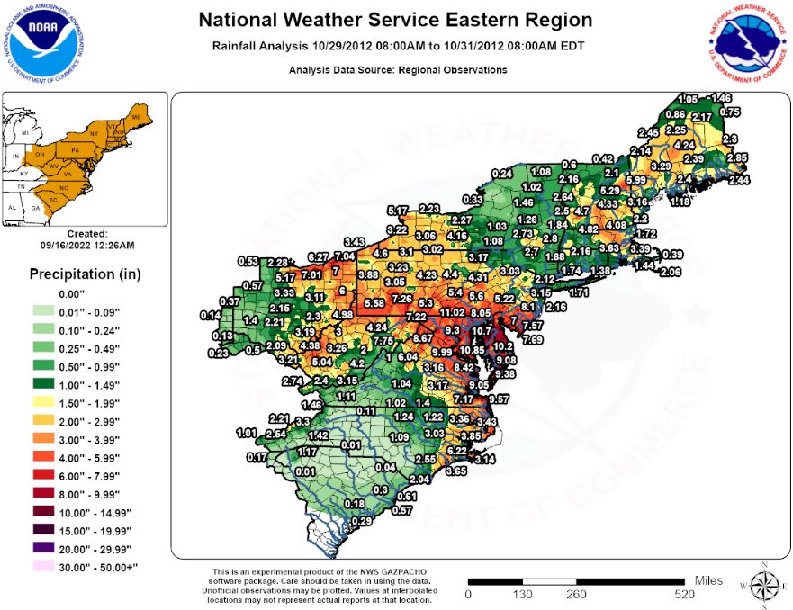
(The National Weather Service)
Drier air to the north cut rainfall totals on the other side of Sandy, leaving less rain across most of New Jersey and New York. As a result, these areas only received between 1 to 3 inches of rain from the storm.
Storm surge
In general, major to near-record storm surge accounted for the bulk of the Sandy-related damages. Strong easterly winds off the Atlantic forced water onshore in New Jersey and into the Raritan Bay, which then drove water levels up in New York Harbor.
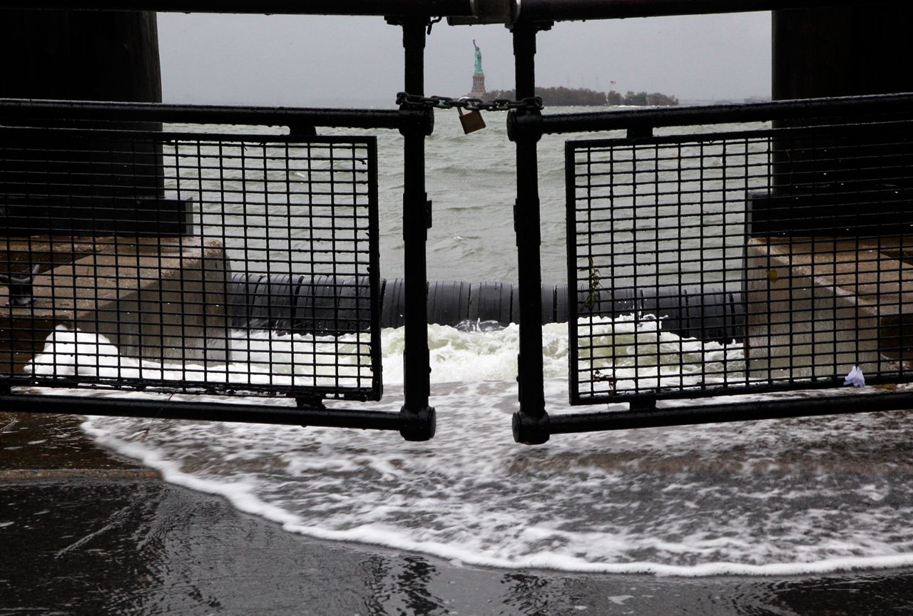
Rising waters in New York Harbor spilled into Battery Park, at the southern tip of Manhattan. (AP Photo/Richard Drew)
This was all made worse due to the fact that it happened right during astronomical high tide, further exaggerating flooding.
As a result, much of the Jersey Shore, as well as New York Harbor and Long Island, were the worst affected areas, with inundation levels reaching between 3 to 9 feet above ground level. Sandy Hook, New Jersey and Staten Island, New York reported inundation levels peaking at 8.9 and 7.9 feet, respectively.
With no other place to go, much of this displaced water was pushed up the Hudson River, causing storm surge as far north as Albany, New York.
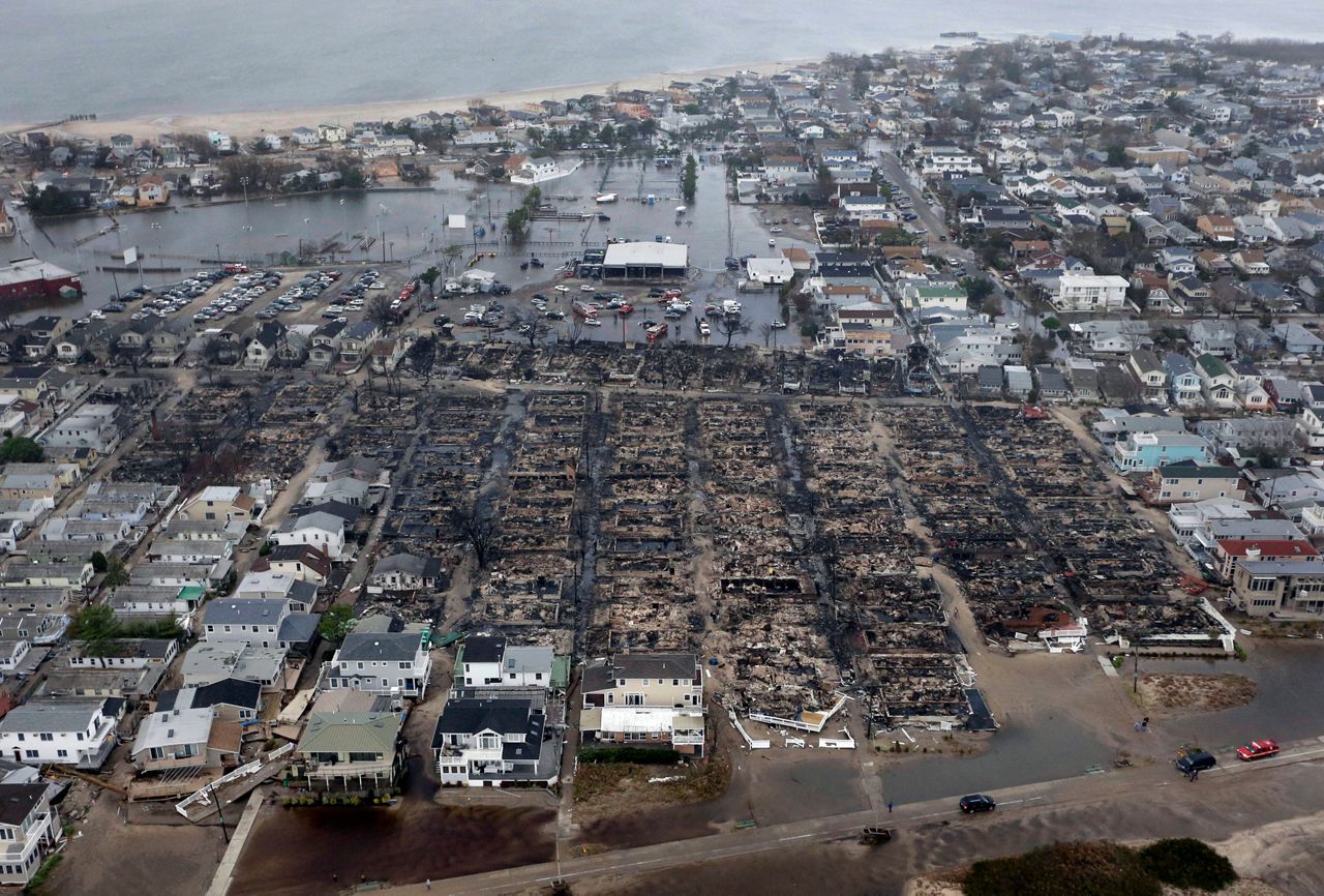
Storm surge inundated Breezy Point, a coastal neighborhood in Queens County, New York. Seawater sparked electrical fires, which burned down over 100 homes nearby. (AP Photo/Mike Groll)
Along with bringing water damage to properties and vehicles, storm surge also initiated electrical fires. Over 100 homes burnt to the ground in Breezy Point, a coastal community in Queens County, New York, leaving many without a home during the worst of the storm.
Despite the damage done, the most permanent damage done by storm surge was the loss of lives itself. Multiple deaths from Sandy were caused by people drowning from storm surge.
Other impacts
Much of the new York and New Jersey coastline faced significant beach erosion from storm surge and high surf caused by Sandy. As a result, dunes were whipped out in many places, leaving roads, homes and other infrastructure unprotected and vulnerable.
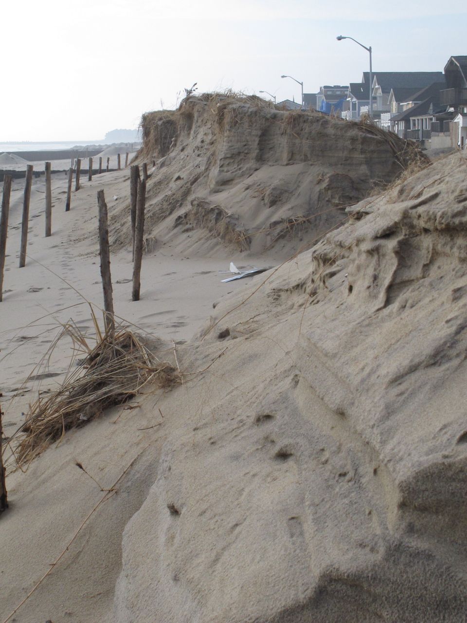
Beach erosion from Sandy damaged dunes in Manasquan, New Jersey. (AP Photo/Wayne Parry)
Sandy was also brought snow to parts of the Appalachians, mainly in West Virginia, Virginia, Tennessee and North Carolina, making it one of the few tropical/post-tropical cyclones to produce winter weather.
Areas that did receive snow saw a wide range in totals, with some places measuring less than an inch and other spots seeing between 1 to 2 feet in accumulations. Snowfall totals even added up to over 3 feet in a few select areas, particularly across the higher elevations of West Virginia.
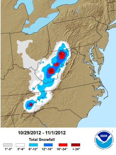
(NOAA)
With that, heavy snowfall combined with gusty winds even brought blizzard-like conditions to some places.
Naming misnomers and other alternatives
Seeing headlines that a hurricane is going to hit to your area sends a more alarming message than a post tropical storm. Although, in the case of Sandy, turning post-tropical didn’t mean it would be less significant that a hurricane.
Given this, being able to still properly communicate the severity of impacts that Sandy was to bring (and brought), became one of the biggest challenges meteorologist faced. The storm would still devastate the Jersey Shore and the New York metro area, one of the most densely populated regions in the nation. As a result, it was titled as a ‘superstorm’ instead.
In addition, Sandy was also known as the “Frankenstorm”, due to its close proximity to Halloween.
Our team of meteorologists dives deep into the science of weather and breaks down timely weather data and information. To view more weather and climate stories, check out our weather blogs section.