Hurricane Idalia made landfall along Florida’s coast early Wednesday morning, after strengthening to an “extremely dangerous” major hurricane overnight.
By the time Idalia made landfall at 7:45 a.m., it was a “catastrophic” Category 3. The hurricane made landfall near Keaton Beach in Taylor County, which is in North Florida’s Big Bend region.
According to the National Hurricane Center’s 8 a.m. advisory, the center of the storm was about 10 miles south-southeast of Perry with winds dropped to 120 mph by 8 a.m. It remains a Category 3.
“This change in wind speed does not diminish the threat of catastrophic storm surge and damaging winds,” the National Hurricane Center stated.
In a 9 a.m. update, the National Hurricane Center said Idalia is about 20 miles south southwest of Madison, Florida. NOAA radar data indicate the maximum sustained winds are now near 110 mph with higher gusts.
Forecasters say Idalia is expected to move in a north-northeastward motion through the morning, with the center forecast to move into southern Georgia later today.
“Idalia is forecast to turn toward the northeast and east-northeast, moving near or along the coasts of Georgia, South Carolina, and North Carolina late today and Thursday,” the National Hurricane Center said.
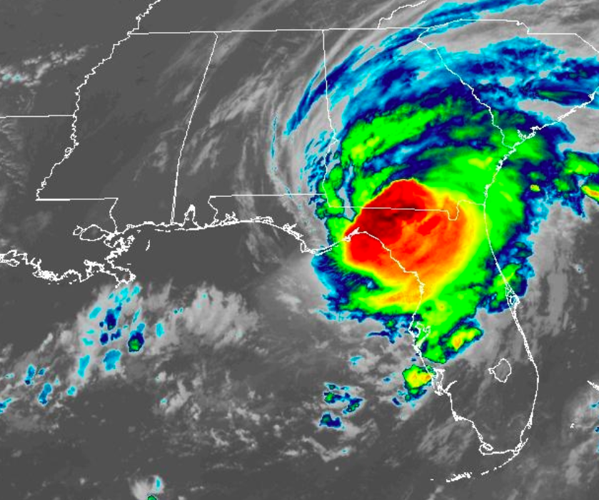
Hurricane #Idalia making landfall in the Big Bend Area this morning with catastrophic storm surge. Surge concerns will continue along the west coast even though is pulling away from our area. Highest surge will be around the time of high tide this afternoon hours. Remain alert!⚠️ pic.twitter.com/kl8VmpJDjA
— NWS Tampa Bay (@NWSTampaBay) August 30, 2023
The advisory also warned of “catastrophic storm surge” up to 12 to 16 feet between the border of Wakulla and Jefferson counties and Yankeetown in Levy County. It surpassed 6 feet in Cedar Key, just south of Idalia’s landfall, by 8 a.m.
The advisory stated that “life-threatening storm surge inundation” can occur in areas where a storm surge warnings are already in effect.
“Although Idalia will weaken further now that the center is inland, it is likely to still be a hurricane while moving across southern Georgia, and near the coast of Georgia or southern South Carolina late today,” forecasters said. “Idalia is forecast to be a tropical storm while moving near the coasts of northeastern South Carolina and North Carolina tonight and on Thursday.”
The National Weather Service placed 26 Florida counties under a tornado watch, now extended until 3 p.m. In Central Florida, Lake Seminole, Orange, Osceola, Volusia and Brevard counties are under a tornado watch.
The National Weather Service Office in Melbourne says impacts for East Central Florida include winds from 25 to 35 mph, with gusts up to 45 mph. Tornadoes are possible. A flood advisory has been issued for parts of Osceola County through 11:15 a.m.
9:20 am | Flood Advisory has been issued for portions of Osceola County thru 11:15am. Minor flood concerns will continue in Kissimmee & Saint Cloud as rain bands from Idalia move over the area. pic.twitter.com/8W2R2SKTmE
— NWS Melbourne (@NWSMelbourne) August 30, 2023
Orlando Weekly will keep an updated list of local shelters, sandbag locations and closures.
Subscribe to Orlando Weekly newsletters.
Follow us: Apple News | Google News | NewsBreak | Reddit | Instagram | Facebook | Twitter | Or sign up for our RSS Feed
A strong geomagnetic storm is expected Friday night. NOAA’s Space Weather Prediction Center has issued a G4…
Not every thunderstorm spawns a tornado, but when they do, the strong rotating wind can…
A large storm system crossed the Rockies over the weekend. It produced rain and snow…
The 2024 Atlantic hurricane season doesn't begin until June 1, but we're already watching an…
Widespread flooding in Dubai last week has people wondering if cloud seeding is to blame…
A system sparking a severe weather outbreak over parts of the southeastern U.S. today will…